
Last weekend my parents came to visit. After they got vaccinated, they went on a road trip, first to Phoenix to visit my sister Leslie and her kids, then to some National Parks (Grand Canyon, Arches, Canyonlands), and then took their time driving through Kansas and Missouri to get to me on a weekend when I had days off. Me, days off on weekends, I still can’t quite get used to it!
Anyway, they arrived last Friday just in time for us to watch my sister Carrie play a recital for her doctoral degree at CUNY. We set up the livestream on the big TV.

Carrie played a great recital with a wide variety of pieces and we clapped after each piece even though she couldn’t hear us. We were all very proud.
After that, I had one lesson to teach before being done for the weekend, so I did that and then we just hung out, took a walk around the neighborhood, baked a dessert, and eventually got takeout from an Indian/Nepali restaurant, Himalayan Yeti. I hadn’t been impressed with them a few years ago, but Louie randomly got dinner there a month earlier and I loved it, so we did it again. After dinner we watched a movie, Nomadland. I like streaming, but in a way I miss the days of just going to a movie store and picking out the movies: we had to do a lot of research and then sign up for a Hulu account in order to watch the movie. Rental prices are crazy, like $20 for a rental, are you serious?
So, a few years ago when my parents were visiting we had considered visiting Columbia Bottom Conservation Area, where you can visit the Confluence of the Missouri and MIssissippi Rivers. We decided against it at that time and did something else, so we thought this would be a good time to do it: easy social distancing due to not being very popular. It was lightly raining, but nothing you couldn’t walk around in. Right before we were going to leave, I thought of checking the website, and I’m glad I did…the website said that due to the floods in 2019 that:
All the area trails have been damaged and are closed. Conditions are rugged and uneven in many places. Users may hike these trails at their own discretion
AND
The road from parking lot L to the confluence is closed. Area users may park at lot L and hike to the confluence (approx. 1 mile)
This information seemed a bit conflicting to us, and we focused on the bit that said “area users may…hike to the confluence”.
So, off we went! We got to the park and found that yes, some of the roads were closed, but we drove through on in the Subaru on the gravel roads and did pass one or two other cars. The birds were out in full force and that was great to see. We found Parking Lot L and parked, and then realized, that yes, the trail was overgrown with weeds and mud. I don’t think we really realized how much damage there still was from the flooding of 2019, and had assumed the website was being dramatic, after all, it had been nearly two years. Nevermind that those years were during a globalwide pandemic and likely there was little funding given to the cleanup.
We decided we would try to get there and worst case, would just turn around and not see the confluence.
It’s important to note that in the past, one could drive up right to a parking lot and just hop out. We had hiked there in the past as well.
Well, we mostly walked along that road, which was mostly overgrown with weeds. It was pretty amazing to see how quickly a road can turn into nothing…I think it was a two lane road and at times it was less than one lane. We walked through some large puddles and a few muddy places, and we kept thinking we might have to turn around, but kept forging ahead.

Can you see the sign that says “Bus Parking”? That’s how overgrown things were.
We finally got to a place when the road completely ended, but found a route through a bush where obviously people had gone, and then I went ahead to see if there was a way through, and found that it was easy enough, just a bit of wandering in the woods.

It may not look like much, but that is the confluence of the Missouri (left) and Mississippi (right) rivers. It was overcast, but you could see a little ripple where they come together, after all those miles and miles. So much of our land and history (and those who came before us, the native Americans as well) are based on these rivers running throughout the country, and it is fascinating to see one turning into the other.

You can see the little point of land before the rivers converge behind us.
We were pretty proud to have made it out there to the edge, without having a real path to follow! We noticed we weren’t at the official viewing area though, just a little bit of land you could see through. We started heading back and then we did find the original parking area:

There is a kiosk there with historical information and a blue pole showing the level of various floods over the years. I suspect 2019 will be the highest yet, if they are able to rebuild. I suppose I don’t actually know if 2019 is the highest yet, but I hope they can rebuild and update it. My dad and Louie are standing in what looks like a yard, but it was a parking area with pavement before, and Louie is holding a “Bus Parking” sign.
Then we realized we might as well try to get back out to the original viewing area, so we found our way there.
You can see the concrete was damaged in the flood and there are several downed trees just sitting around.

It really seems like quite a bit of damage, all caused by water. Seeing this really gave us a greater understanding of the power of water, somehow even more than the Grand Canyon, because this just happened!
Finally we headed back, and knowing what we were hiking through made it easier than the way out.

If you look carefully into the green, you’ll see a faint blue square. It is a disabled parking sign. Not a great place to park at the moment, though I joked that those weeds could have grown up in a week, knowing how weeds in my own yard work!
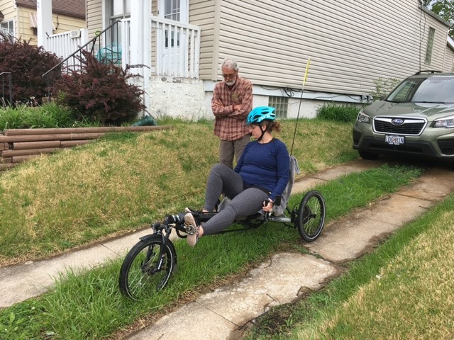
Afterwards, we came back and took turns riding my dad’s electric
“trike.”


I was a little nervous to take it out, but I went around a few blocks and it was actually super fun and exhilarating to ride!
Later we cooked dinner and watched the movie Knives Out.
The next day we went to Louie’s mom’s for brunch. Everybody except Louie’s brother Julian was fully vaccinated, and Julian had gotten his second shot just that morning. We had a lovely meal and then took a long walk around Forest Park. It was a hot day, actually, and we enjoyed seeing all the flowers and such. After that it was time for our weekly “roll call” online zoom meeting with the rest of the family and then dinner. We watched the Oscars after dinner for a bit, but went to bed earlier.
I woke up earlier to teach my class but then my parents didn’t leave until a few hours later. It was great to see them, especially after so long, and I hope I didn’t make them walk too much.
They took two days to drive home but did get home safely.


My mom taught me what some of the flowers were called: I guess this is the first year I’ve really paid attention to what is coming up. Anyway, the second two above are irises ![]()
Have you visited the Confluence?
I’m so glad you shared this… I didn’t realized that it had flooded and needed help. Ready to start the “save the confluence park” fund?