I’d been feeling a bit overwhelmed by what would be my last trip post, if I kept the same pattern of two nights, and then I said to myself, this is MY blog, nobody except me and my mom reads it, so why not break the last post up?
So far I’ve told you about Little Rock, Hot Springs, and our wonderful cabin in the Ozarks near the town of Pettigrew. Our next airbnb was south of Fayetteville where we would be spending our final two nights of vacation, but I wanted to make a stop en route.
I like seeking out National Park Sites, not for a bucket list or anything, but because they are often well done and worth visiting, and I enjoy learning about history as we travel. I noticed that Fort Smith National Historic Site wasn’t too far out of the way, and I’d also found a blogger who really loved the town of Fort Smith, so we decided it was worth a short visit.
I wasn’t sure if our google directions already took the gravel roads into account when telling us how long it would take to get there, but it turned out they did. It took about 1 1/2 hours to get to Fort Smith, so we rolled in somewhere between 10 and 11. Fort Smith is located right on the western border of Arkansas by the Arkansas River, and our directions had us briefly in Oklahoma, which was very exciting.
That is Oklahoma.
The Visitor’s Center was closed due to COVID but there was a ranger sitting outside with a table of brochures and happy to answer any questions. I’m sorry we missed whatever museum would have been inside, but he said otherwise, just walk around and it is all well marked.
Various pictures from the route. There was a bit about Fort Smith itself, fighting against Native Americans and stealing their land and the Trail of Tears, things about the Civil War, a supplies area, and a garden.
It seemed that the Fort was important in its history in regards to the Civil War and the Trail of Tears. Some of the information we read was a little confusing out of context, for instance we read something about the soldiers at the Fort abandoning the town when South Carolina seceding from the Union, but then later referring to the soldier being there fighting…so maybe that visitor’s center museum would have been helpful? Or a book I suppose.
In any case, it was a nice place to walk around. There was an extra long walk one could take down by the river, which added about 3/4 mile (I am just trying to remember this without research, so I could be wrong). We enjoyed a nice walk along the Arkansas River. We’d had dinner along the Arkansas River and crossed it a few times by foot in Little Rock and now we were seeing it again on the other side of the state.
It was a lovely, shaded walk on a hot day.The sign was at the edge of the property on the walk, not near the parking lot. Does that mean that the US is becoming a more pedestrian country?
After about an hour, we had seen all we could see. There weren’t proper restrooms at the site, so we figured we’d go and find lunch and bathrooms at the same place.
We drove down a very quaint, historic looking downtown strip to find a place called A.J.’s Oyster House. It was perfect: friendly, cool, had bathrooms, and we enjoyed some oysters too. I got the Oyster Po’boy and we split some Oysters Rockefeller.
After lunch we decided to pop back over to the downtown area to walk around, but I got distracted by a sign about Victorian Homes, and we ended up walking by some of them instead. They all seemed to be law firms now.
We couldn’t check into our airbnb until 3 pm and it was an hour away, so after our stroll we got coffees and relaxed at the Fort Smith Coffee Company (super cool place!) until it was a reasonable time to take off.
Keep your eyes out for the final, or who knows, installment of the trip to Arkansas!
I was looking through old pictures and found some from a previous visit to the confluence (2015). I blogged about visiting the confluence (of the Missouri and Mississippi Rivers) the other weekend with my parents and how there was a ton of flood damage.
Here’s a picture from two weekends ago:
And this is a different angle of the same kiosk, you can see the pole is there which showed the height of flooding in 1993.
You can see there was a parking lot and such, none of that is visible, it is all covered with mud and plants now.
Here is a selfie I took before—you can see there is a metal bar in the background.
Another picture of the viewing deck of the confluence in the past. Look in the background at the trees—that’s the last bit of land before the confluence actually happens.
This is a different view, but it’s the same platform. The metal bars are totally gone. When we there recently we didn’t even notice they were missing, but now I see it.
My mom standing on the platform surrounded by flood wreckage.
And now, two similar pictures of the actual confluence:
Can you tell which is which? Probably only because the bottom one is from the summer and the upper one is from the winter. So the first one is from the other week, and the second one (directly above) is a picture of the confluence from 2015.
I found all of this to be really interesting, and I’m glad I was able to find these photos from 2015 (it was a bit of a search!).
Last weekend my parents came to visit. After they got vaccinated, they went on a road trip, first to Phoenix to visit my sister Leslie and her kids, then to some National Parks (Grand Canyon, Arches, Canyonlands), and then took their time driving through Kansas and Missouri to get to me on a weekend when I had days off. Me, days off on weekends, I still can’t quite get used to it!
Anyway, they arrived last Friday just in time for us to watch my sister Carrie play a recital for her doctoral degree at CUNY. We set up the livestream on the big TV.
Carrie played a great recital with a wide variety of pieces and we clapped after each piece even though she couldn’t hear us. We were all very proud.
After that, I had one lesson to teach before being done for the weekend, so I did that and then we just hung out, took a walk around the neighborhood, baked a dessert, and eventually got takeout from an Indian/Nepali restaurant, Himalayan Yeti. I hadn’t been impressed with them a few years ago, but Louie randomly got dinner there a month earlier and I loved it, so we did it again. After dinner we watched a movie, Nomadland. I like streaming, but in a way I miss the days of just going to a movie store and picking out the movies: we had to do a lot of research and then sign up for a Hulu account in order to watch the movie. Rental prices are crazy, like $20 for a rental, are you serious?
So, a few years ago when my parents were visiting we had considered visiting Columbia Bottom Conservation Area, where you can visit the Confluence of the Missouri and MIssissippi Rivers. We decided against it at that time and did something else, so we thought this would be a good time to do it: easy social distancing due to not being very popular. It was lightly raining, but nothing you couldn’t walk around in. Right before we were going to leave, I thought of checking the website, and I’m glad I did…the website said that due to the floods in 2019 that:
All the area trails have been damaged and are closed. Conditions are rugged and uneven in many places. Users may hike these trails at their own discretion
AND
The road from parking lot L to the confluence is closed. Area users may park at lot L and hike to the confluence (approx. 1 mile)
This information seemed a bit conflicting to us, and we focused on the bit that said “area users may…hike to the confluence”.
So, off we went! We got to the park and found that yes, some of the roads were closed, but we drove through on in the Subaru on the gravel roads and did pass one or two other cars. The birds were out in full force and that was great to see. We found Parking Lot L and parked, and then realized, that yes, the trail was overgrown with weeds and mud. I don’t think we really realized how much damage there still was from the flooding of 2019, and had assumed the website was being dramatic, after all, it had been nearly two years. Nevermind that those years were during a globalwide pandemic and likely there was little funding given to the cleanup.
We decided we would try to get there and worst case, would just turn around and not see the confluence.
It’s important to note that in the past, one could drive up right to a parking lot and just hop out. We had hiked there in the past as well.
Well, we mostly walked along that road, which was mostly overgrown with weeds. It was pretty amazing to see how quickly a road can turn into nothing…I think it was a two lane road and at times it was less than one lane. We walked through some large puddles and a few muddy places, and we kept thinking we might have to turn around, but kept forging ahead.
Can you see the sign that says “Bus Parking”? That’s how overgrown things were.
We finally got to a place when the road completely ended, but found a route through a bush where obviously people had gone, and then I went ahead to see if there was a way through, and found that it was easy enough, just a bit of wandering in the woods.
It may not look like much, but that is the confluence of the Missouri (left) and Mississippi (right) rivers. It was overcast, but you could see a little ripple where they come together, after all those miles and miles. So much of our land and history (and those who came before us, the native Americans as well) are based on these rivers running throughout the country, and it is fascinating to see one turning into the other.
You can see the little point of land before the rivers converge behind us.
We were pretty proud to have made it out there to the edge, without having a real path to follow! We noticed we weren’t at the official viewing area though, just a little bit of land you could see through. We started heading back and then we did find the original parking area:
There is a kiosk there with historical information and a blue pole showing the level of various floods over the years. I suspect 2019 will be the highest yet, if they are able to rebuild. I suppose I don’t actually know if 2019 is the highest yet, but I hope they can rebuild and update it. My dad and Louie are standing in what looks like a yard, but it was a parking area with pavement before, and Louie is holding a “Bus Parking” sign.
Then we realized we might as well try to get back out to the original viewing area, so we found our way there.
You can see the concrete was damaged in the flood and there are several downed trees just sitting around.
It really seems like quite a bit of damage, all caused by water. Seeing this really gave us a greater understanding of the power of water, somehow even more than the Grand Canyon, because this just happened!
Finally we headed back, and knowing what we were hiking through made it easier than the way out.
If you look carefully into the green, you’ll see a faint blue square. It is a disabled parking sign. Not a great place to park at the moment, though I joked that those weeds could have grown up in a week, knowing how weeds in my own yard work!
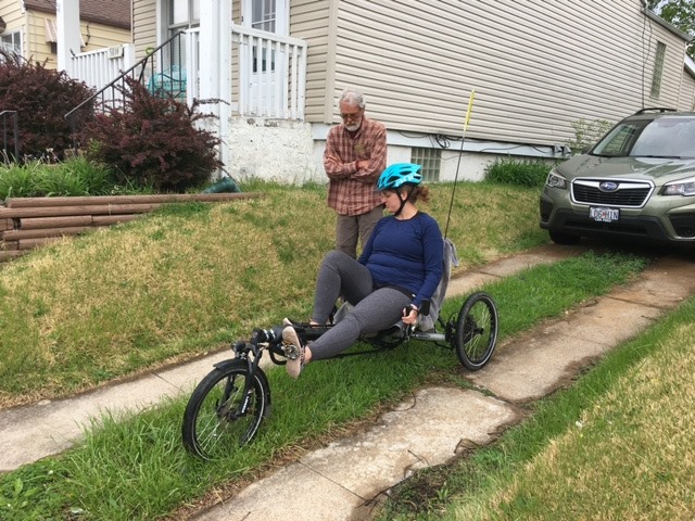
Afterwards, we came back and took turns riding my dad’s electric “trike.”
I was a little nervous to take it out, but I went around a few blocks and it was actually super fun and exhilarating to ride!
Later we cooked dinner and watched the movie Knives Out.
The next day we went to Louie’s mom’s for brunch. Everybody except Louie’s brother Julian was fully vaccinated, and Julian had gotten his second shot just that morning. We had a lovely meal and then took a long walk around Forest Park. It was a hot day, actually, and we enjoyed seeing all the flowers and such. After that it was time for our weekly “roll call” online zoom meeting with the rest of the family and then dinner. We watched the Oscars after dinner for a bit, but went to bed earlier.
I woke up earlier to teach my class but then my parents didn’t leave until a few hours later. It was great to see them, especially after so long, and I hope I didn’t make them walk too much.
They took two days to drive home but did get home safely.
My mom taught me what some of the flowers were called: I guess this is the first year I’ve really paid attention to what is coming up. Anyway, the second two above are irises
I am finally ready to write about the next few days of our trip. We are back home and work is crazy…I’ve been teaching about 22 hours a week and adding more. I’m also taking advantage of a variety of online seminars and workshops to improve and inspire my teaching (since, that’s all there is here. Hopefully someday there will be live performances again but it should be known that the live music and live theater business is currently dead and numerous family members and friends are completely out of work and scrambling to make ends meet.)
So, part 1 here. We drove from St Louis to Yellowstone National Park. I was not under the impression that Yellowstone would be less busy than in normal years, because I knew that visitation was slightly UP but I also knew there wouldn’t be large tour buses of tourists and I knew that it was easy to avoid people if you avoided certain areas at certain times…plus the park is outdoors.
We spent the night camping at Buffalo Bill State Park (normally in my head I substitute “bison” for “buffalo” but don’t do that in this case.) We left and headed west to Yellowstone National Park, only about 1 hour away.
The trick to a park like Yellowstone is to be eager to stop and get out of the car. Along the drive there are numerous small pull offs and each one is there for a reason. It’s easy to want to just sit in the car, but if you get out and look at the sign and admire the scenery (or take pictures) you’ll really get a lot more enjoyment out of it.
Before officially entering the park we had to stop for a bathroom break (have I mentioned how often I have to stop? I never think of it until I can’t just go, like on road trips…also it’s important to hydrate when at high altitudes, which Yellowstone is.)
Our general plan for this first day was to get to our campsite at Madison Campground by late afternoon. We were entering the park at about 11 am, and decided we would do a short hike at Storm Point on our way. This was a hike we’d done the previous year, but it was both easy and really beautiful so we thought it would be a nice “stretch your legs” hike. It was! Even though we made a few mistakes at the beginning…we decided to do the loop hike the opposite direction from the previous year, but we didn’t realize maybe the hike had been slightly rerouted due to a creek crossing and the reverse direction we took wasn’t actually the official trail and we had to do a little bushwhacking to find our way(this is a bit of foreshadowing….this turned out to be an error we made again later). Not very smart! It was also a bit buggy, which wasn’t my favorite, but hey, still better than Missouri, right? The views at the farthest point of the trail, Storm Point, are really gorgeous. You can see Lake Yellowstone and all of the mountains around. We also got to walk down to a little beach by the Lake, which led to Louie asking my favorite question of the vacation: while gesturing at a medium-sized group of ducks he asked, “why are there ducks here?”.
You can see some “thermal features” along the water there. You might think that all of the geysers and such are well labeled and in popular areas such as Old Faithful, but there are thermal features all over, and I love being on a hike, hearing something gurgling and saying “aha, a thermal feature!” Or seeing some “evidence of thermal activity”, another favorite.
This was the little beach area where Louie questioned the existence of the ducks.
We ate our picnic lunch along the way as well, but I think we didn’t enjoy this hike as well as last year because there were a lot of people on it. Normally that wouldn’t bother me, because a lot for a Yellowstone hike means maybe you see 20 to 30 people, but in these COVID times that seems like a lot!
We headed on our way then, just stopping at little things along the way to Madison Campground.
This was Beryl Springs, which is one of the hottest springs in the park. It’s a little pull off, but you see the steam before you park.
We checked into Madison Campground, our home for the next four nights. We hadn’t stayed here before. I had reserved a small tent site, and let me tell you, emphasis on small. Normally I have poo-pooed people who complain about National Park Campgrounds being jammed in too close together. That was my mistake. This site was outrageous. We were basically next to neighbors on both sides, just crammed in the middle of two campsites, with no sense of privacy (not even the pretend privacy of a campground). This was, other than the location being in Yellowstone, possibly the worst campsite I have ever had. For the record (again, the record), you don’t get to pick your campsite at Yellowstone. I’m not sure how they are assigned, but I definitely got unlucky. I have been lucky many times in the past though so I guess it evens out.
In any case, as we pulled up to our site, it started raining. We thought, let’s get the tent down before the ground gets wet. Which in theory might work, and we did it, we put the tent up in record time, but then it started pouring rain, even tiny hail, and it was a horrible storm and of course the ground was wet anyway. That always makes dinner difficult, so we though, hey we are only 30 minutes from West Yellowstone, let’s go there. So we did, but in these COVID times, you can’t just go get food. It was cold, rainy, and nothing appealed and it all just seemed too difficult. The only drive-through, McDonalds, was backed up a block down the street, so we decided to go back to the campground and eat in the car. We drank beers in the car (we decided with the keys out of the ignition there was no one who could argue we were intending to drive) and had hummus and pita chips.
The next morning we got up early. Luckily the rain had stopped by the time we went to sleep so it wasn’t too wet around…it was time to hit the trails and the Grand Loop Road again. We decided to start “easy” with a short hike up to Monument Geyser Basin—2 miles RT which seems easy, but it was very steep! I was definitely feeling the altitude and huffing and puffing but at least it wasn’t too long. The hike was lovely, with conifers all around and lots of rocks. Monument Geyser Basin has some dormant geysers but lots of huffing and puffing from them, with cone geysers, some mudpots and plenty of gurgling and steam. All in a private setting, no boardwalks or fences, just a few branches blocking off where is likely safe to walk and common sense (that you don’t get close to geysers because the ground around them can be very thin).
We enjoyed a little snack while watching the action. We probably only saw about 3 or 4 other small groups of hikers on this hike.
The hike DOWN was much easier, and soon we were back at the car. We decided to continue heading north and just do stops along the way, so that’s what we did. I have a book called “Yellowstone Treasures” by Janet Chappelle which tells you every pull off and what there is there, so that was quite useful on this trip.
Chocolate Pots—unmarked pulloff with some cool brown thermal features.
Frying Pan Spring. This has a boardwalk to it. I was entertained by passing a woman holding a large bag of Bugles for her trip to the Spring. To be clear: these springs tend to stink, and aren’t the sort of thing you want to snack while watching, but to each their own.
This was the kiosk at the pulloff for Obsidian Cliffs, which is the oldest of its kind in the park. It was built in the National Park Service Rustic style, also called “Parkitecture.”
We decided to go all the way to Mammoth Hot Springs and do another hike there, the Beaver Ponds Hike. It was busy when we got there around 2:30, but we found parking eventually (just be willing to walk more!). We masked up and headed for our trail head. The hike was a 5 mile loop and had some elevation at the beginning but wasn’t too bad throughout, according to the information I had.
The view of Mammoth Hot Springs as we were going by.
We climbed a bit and ran into a couple of teenagers coming back towards us asking about the trail…they had lost it further up and wondered if we knew. We did not, but said we thought we were on the right trail and that was that. A bit later we saw what we thought they might have done wrong (there was a turnout one way to an overlook, the other way to continue the trail) but weren’t sure how they could have missed it. In any case we followed along, enjoying the hike, and even saw a few coyotes (I think?) at one point (which we realized were hunting a marmot…which yes, it’s the circle of life but I don’t enjoy watching animals try to kill other animals.)
If you look closely you can see the coyote. Louie probably has better pictures from his DSLR.
We got to the Beaver Ponds (two of them, I think? ) and kind of followed around.
Suddenly we found ourselves on a trail that seemed less traveled and started to worry we had taken a wrong turn. It didn’t seem super wrong, just a little wrong, so we kept going, and found ourselves going up this steep trail on the side of the trail that was just covered with animal poop (elk, likely) and that’s when we thought, this doesn’t seem right. I had a picture of the map and we looked at it, but it didn’t help. I started panicking. I think I may have started saying, oh my god we are lost in Yellowstone and we are going to die out here and nobody knows where we are and was really starting to have a panic attack. We should have turned around, but we thought we could find the trail. I thought I didn’t even have a topographic map and it was just frankly, really terrifying. I knew if we headed east we would eventually hit the Old Gardiner Road but I didn’t know how far that would be nor if it would be easy to get to, but that was all I could think…
Louie stayed calm and tried to get me calm, and we were on a sort of trail, because there were footprints here and there, but we just couldn’t get going the right way. Finally he got some cell services and could see our location on the maps, and he was able to see where the trail was compared to where we were! Unfortunately, it was up a very steep hill, which had a variety of ways up but they all seemed to be absolutely terrifying (to me) paths made by the elk. I kept having to stop and was really on the verge of absolutely full on panic, but after some harrowing minutes (maybe even an hour, I don’t even know, I couldn’t think straight) we made it up this horrible hill and over the ridge and then finally back on the trail.
Here’s the thing you should know: before the trip I downloaded two apps on my phone, and both had the complete trail system of the park on them, one with the trails marked, one with topographical maps. Both of them show your location in real time on the map, and neither require cell service, only GPS. But in my panic, I didn’t think of trying them out. I also didn’t think of using the GyPSy app we had been using, which ALSO knows our location, and incidentally, has trail maps on it. So I had my phone, with nearly full service, but didn’t have the calm mind to use it to try to help ourselves. Louie did want to sit down and just regroup but I just couldn’t do it.
I will tell you, I was never so happy to be back on a trail. I don’t know why I got so absolutely panicked but it turned out okay and I definitely overreacted. I think it was because the pandemic has just left me so constantly stressed that I didn’t have anything left.
We were both incredibly happy when the town and the Hot Springs were in view!
We passed by (carefully) some elk in town (this is super normal, it is weird if you DON’T see elk in the town of Mammoth. And then decided to take a look at the Upper Loop Drive. There was a place where normally you can drive through but for some reason was closed to cars, so we decided to walk it instead. After that we visited Canary Spring, one of our favorites from the previous year (we stayed a night in Mammoth). It’s an amazing spring going down over the terraces. We did notice some parts that had been active the previous year weren’t this year, but I can’t believe that apparently now Canary Spring has gone dormant! Although I think it was a bit drier from my pictures, it was still really amazing. (They say the only constant in Yellowstone is change, and that one spring will go dormant but another will start up again).
Finally we decided we’d better head back to the campground to make dinner. It took over an hour to drive back—we saw a few more elk along the way but nothing too crazy. We made a fire and made dinner and hung out a bit before going to “bed.” Oh, and I think it HAD rained/stormed at the campground but luckily we had a rain free day—the clouds looked menacing on our Mammoth hike but luckily it held off: we had enough challenges there already!
The next day we headed north from the campground again, and just figured we’d make a lot of stops as well and do a hike or two later in the day further along. First we made a quick stop at Terrace Springs and enjoyed being among the first there.
Our next stop was Gibbon Falls. It was a very busy parking area especially for the early hour so we kept our distance.
We did manage to get a selfie with the falls.
Then we decided to hit Artists Paint Pots. It was already a fairly crowded area but we got a space. It wasn’t too crowded other than the parking lot (which is quite small.)
There are a ton of thermal features here and a gorgeous mountain range for the backdrop.
We visited Sheepeater Cliffs (we almost didn’t do this because it seemed to just be a picnic area, but it was awesome.)
We drove past Mammoth then, and decided to leave the park to go into the town of Gardiner to check email and such. (Also Louie hoped to see Elk in the river along the way.) It was very exciting to get LTE service in town (which is only 5 miles from Mammoth).
Terrible picture, but the lions outside of the Post Office are wearing masks, you can see.
Elk near the Roosevelt Arch, which is at the North Entrance.
We got a fruit smoothie in Gardiner at a sort of food truck and walked around a bit. Then we headed back to the park, and on the drive back in we did see a bunch of elk down near the river—it was a hot day and there were dozens of them enjoying the water. I wondered if some of the trails we were accidentally or on purpose following during our hike the day before would have led us to the river?
We watched for awhile and then headed on.
We drove the Blacktail Plateau Drive which was pretty but had no wildlife sightings other than a strange bird. I think it was too hot for the animals, but we figured we’d try it anyway.
We had decided to do the Lost Lake/Petrified Forest Loop Hike. I’d thought we could start from Roosevelt, but it really was closed (COVID) so we started the Petrified Forest instead. This was a 3 mile round trip hike with some elevation. What I didn’t realized was the second half was mostly uphill and ALL in the sun, so it was less pleasant. I also should have had my hiking sticks in places, because I got a bit scared and cranky. The first part of the hike was lovely, by a beautiful lake, down through a wooded forest, into the Roosevelt area, full of cabins, and not much else.
(The lake wasn’t lost at all, very easy to find!)
A few people were around working, and we asked directions to get to the other side of the hike. The area seemed a bit post-apocalyptic with all the buildings being completely abandoned. The next part of the hike was not my favorite and was lots of climbing with not much shade, and it was the heat of the day. I don’t remember Yellowstone being so hot, but this visit it was!
Anyway, we did check a few times to make sure we were still on the trail, using my excellent maps with my GPS, and it was uneventful in that way.
After the hike we had time to visit Lamar Valley briefly and see the bison. There are just hundreds of them, and I always enjoy seeing them.
We thought we might have a 2 1/2 hour drive back home (I think it ended up being about 2) so we had to leave before too long. We did get in a nice bison jam, and at one point a bison was walking down the road right in front of us. We’d heard they can travel up to 35 mph, but this guy was just going about 3 mph…finally he got over into the other lane and Louie though it was safe enough to pass. He wasn’t actually sure about it, and it is a little nerve wracking driving by the bison but the fellow didn’t seem to mind us slowing driving by.
We made very few stops on the way back, but did stop at Apollinaris Spring. It was a place that you used to be able to drink the spring water and had this amazing stone work around it. Now it’s all overgrown, but it was beautiful in a haunting way. Yellowstone has natural beauty, and also quite a long history (and before it became a park too, you’ll read things about Native Americans living on this land long before, but then you’ll also read about how “nobody lived here” which is…GRRRR.)
Don’t mind Louie being on the edge of my photo.
It was just off the road, not well marked, and we initially didn’t stop because we didn’t see anything there. Another random Yellowstone find that we really enjoyed (and NOBODY was there except us and the mosquitoes).
Then it was dinner time, and campfire time. The good thing about having squeezed into our tiny spot was that it was easy to bring things from the car to the picnic table. And luckily, each night the people right by us were perfectly nice and not too loud (other than one night when were near a snorer, who I was convinced was a bison briefly).
I’ll stop there and you can wait a few weeks (maybe not that long!) for the next installment of our trip! One more night in the Madison area, then a night in West Yellowstone, and then over to Bridge Bay campground. Check out the map of Yellowstone to get a sense.
We decided to take advantage of the decent weather yesterday (and less things to do so that we could both afford a day trip) and drive about 90 minutes to hike Buford Mountain. Initially we just planned to hike about 6 miles to Bald Knob and back, but when we got there I was feeling great and so we decided to add on the extra 4 miles of the loop…I did regret that from about miles 7.5 to 10 and especially when I ran out of water (never forget: fill up ALL 3 liters in your water bladder) but it was a great diversion and a tough hike that took us away from St Louis and COVID for awhile. Buford Mountain is often found on lists of “the hardest hikes in Missouri” but don’t let that scare you if you are in decent shape: just pack lots of water and snacks and print out a map before you leave. It gets buggy in the summer though, and we beat that time of year, luckily. The hardest hike in Missouri is tough, but not like, say, the hardest hike in Colorado.
Along the way we had to make one pit stop-we had hoped to not have to but my bladder didn’t cooperate. We stopped at a Casey’s General Store and the only other people wearing masks were the workers. It was concerning, but I got in and out quickly and then sanitized my hands before reentering the car.
We got back and made a frozen pasta dish from Katie’s Pizza. We’ve ordered from them a couple times for frozen pizza and pasta. The pasta isn’t my favorite but it’s good. The pizzas are GREAT. We’ve become sort of addicted to the Morel Mushroom ones even though they are pricey.
Today is a relaxing day: it’s hot but I am trying to postpone the airconditioning until it’s more humid, so we’ve got windows open and fans going. We’ll see how this goes. (Note, it went about for thirty more minutes and we caved.)
I found this picture somewhere and laugh every time I think about it.
It’s my nephew Luca’s first birthday, so we have a family zoom meeting later. I made a small batch of lemon cupcakes in his honor—the batch made only 4 cupcakes, which is just about perfect for the two of us. I even froze the other two, but likely we will eat them in honor of my Dad’s birthday on Wednesday. I think they’ll stay fresher in the freezer however. They are lemon, with a strawberry jam filling with lemon cream cheese icing and should be pretty good. I don’t think I’d made cupcakes since I was a little kid, but I think I did an okay job.
This week looks to be pretty much the same as always. We are mostly still staying-at-home so that’s what we are doing. I suppose we’ve done a bit more going out and about, but we’ve been definitely continuing to practice social distancing, and plan to continue to do so for the future, until we see proof that relaxing standards isn’t causing a rise in deaths.
It was a gorgeous weekend, weather-wise, so Louie and I took a hike one day. There had been an article in the local paper about various places to hike and it mentioned Cliff Cave Park. I had had it on my list for a bit, but it often seemed to be flooded. I assumed (incorrectly) that since the article mentioned no flooding that the park would be fine to hike.
To be fair, we were still able to hike several miles, but a long part of the hike was closed due to flooding. Dear reporters, don’t just google stuff and put together an article. Maybe go check it out.
Anyway, it was a lovely day and we enjoyed walking around near the Mississippi River. We probably walked about 4 miles total.
Otherwise, the weekend flew by. For once we didn’t have any concerts to attend, but I had a bunch of rehearsals and a few students, and before we knew it, it was Monday again.
I have now done a fair amount to “prepare” for coronavirus disruptions. We probably have two weeks of food and 3 days of water (for whatever reason) so I feel better about things. I suppose I’m tired of feeling like everything is terrible and feeling helpless and that our president is a completely narcissistic fool and yet so many of my fellow Americans are…well, fine with that. It’s upsetting.
I’m also annoyed that we don’t get to vote in the primary today. I’m annoyed that we don’t all vote on the same day: the concept of momentum is stupid, and we should all just get to vote on the same day (or week, really) for the candidate we think would do the best job. Perhaps even the top three candidates, in order, and then the one who got the most votes would become the nominee. Why does the primary season feel like it’s been going on my whole adult life?
In any case, the weather is beautiful, I don’t have to teach until 1 pm, so maybe I’ll get out for a run! Sorry there aren’t any cat pictures——I ‘ve been too busy to take any, and honestly, she just does the same things


