Category Archives: Travel

Arkansas Travelers: Two Nights in Little Rock

A few years ago we spent a long weekend in Eureka Springs and had a great time, so when I started thinking about post-COVID vaccine trips, I thought of Arkansas. I wanted to go somewhere not too far away, and somewhere that wouldn’t be overwhelmingly busy with tourists, as I knew the more famous places would be slammed with people eager to travel.

I decided to put together an 8 night road trip for Louie and I that hit the best of Arkansas, or at least, 4 different areas for two nights each.

So, we started with two nights in Little Rock, the state capital. I booked an airbnb in downtown for these leg of the trip. We left on a Saturday morning and headed south.

It’s about a 5 1/2 hour drive to Little Rock, and most of it is on state highways. It was interesting to see the little towns along the way and watch the landscape go by.

We stopped at a McDonalds in Arkansas for a late lunch, and were surprised that we couldn’t eat inside the restaurant. (We actually failed to notice that they were closed inside and were about to sit down and eat and they had to tell us that we couldn’t, which was mildly embarrassing). Missouri has been so “open” this whole time with few restrictions and it was odd to think that a neighboring state had some. That being said, few people were wearing masks, including people going into that same McDonalds, so it’s not like Arkansas was doing things better, just different.

Anyway, we got to our airbnb at 3 to check in but due to a mix up had to wait a little longer. We walked over to a nearby coffee shop in the SOMA area called Community Bakery and sat outside to enjoy some coffee and cookies.

The SOMA area was a 5 minute walk from our airbnb, and SOMA just means South Main Street. It was a few blocks with a bunch of restaurants and a few other things to do, and was really cute. We walked around a bit after our coffee and then went to check into our place.

We were staying in a little apartment in a house with a shared kitchen and other shared spaces, but with private areas. It worked out really well and the hostess actually wasn’t even around for the rest of our stay, so we had the place to ourselves at a cheaper rate!

We walked down to the river next, and took an hour or more just looking around, taking pictures, and getting a sense of Little Rock.

IMG_8380IMG_8381

IMG_8383IMG_8387IMG_8389

There is a park called Riverfront Park right down by the River which has art and playgrounds and other cool stuff to do and look at. You can also bike or walk along the Arkansas River Trail which is a much longer trail.

We had dinner reservations for a place called Brave New Restaurant, so after awhile we cleaned up and headed there. This wasn’t our first dinner out after getting vaccinated, but it was our first fancy dinner, and I was really looking forward to it! Though it was a bit chilly we sat outside on the patio overlooking the Arkansas River. It was absolutely beautiful as the sun went down!

The food was excellent too: oysters, salad, trout…it was all delicious and well prepared. The chef, Peter Brave, kept coming around to check on all of the diners and make sure we were enjoying our food. We loved the meal and would eat there again!

The next morning we decided to grab coffee and breakfast at the Community Bakery and then go to hike up Pinnacle Mountain at Pinnacle Mountain State Park.

IMG_8402

We had a little trouble finding the right parking lot at first due to Google not being as helpful as we needed, but we eventually found the West Summit Trail Trailhead with plenty of time to beat the crowds.

IMG_8404

It was a lovely trail, for awhile, until it just turned into some rock scrambling!

IMG_8405

The rock scrambling part (unpictured) was terrifying to a point, and I had to sit down for awhile. I didn’t think I could finish and Louie went ahead without me, but after collecting myself and resting I decided to forge ahead and made it to the top!

IMG_8406

IMG_8408

After hiking, we went back to the SOMA area for lunch and went to a wonderful place called the Root Cafe. We just beat a large crowd, but were told it would be 40 to 50 minutes on our food anyway! This ended up being wrong, and we were eating within 20 minutes. I had a delicious banh mi tofu sandwich and Louie had a mushroom burger.

IMG_8417IMG_8419

After lunch we decided to visit the Historic Arkansas Museum (called the HAM). It was okay, and sort of interesting, with old houses outside and some indoor displays, but I was hoping for a bit more on the actual history of Arkansas for general knowledge about the state and the area, and it was piecemeal. It was partly our fault for not doing the call in cell phone tour, but I’m not that interested in going to a museum and using my cell phone… I want to be in the moment at the museum, experiencing and reading stuff, and honestly, I use my phone for taking pictures and it can be tricky going back and forth. In any case, one of the more interesting things to me was that the old houses were actually there from the start of the museum in the 1930’s and the museum itself kept them from being torn down!

IMG_8422IMG_8424IMG_8426

We walked over the Bill Clinton Presidential Library after that. We knew it was closed due to COVID but wanted to see the grounds and the building anyway, and there was plenty to do outside, some gardens, wetlands(so many turtles!!), and artwork area. It was a really cool building and I’m sorry we didn’t get to see inside!

IMG_8427IMG_8430

The Heifer International Headquarters are there too, but there didn’t seem to be anything we could do there at this time either.

IMG_8432IMG_8429IMG_8431

We walked across that bridge and considered looking at the other side as the map indicated a trail, but it didn’t look very welcoming so we turned back.

IMG_8445

IMG_8446

IMG_8448

Our next stop was a brewery near our airbnb called Stone’s Throw Brewery. We got a nice sampler and sat outside enjoying the gorgeous weather: it was in the 70s!

IMG_8450

We went back to the SOMA area for dinner to Mockingbird Bar and Tacos. It was tasty and we enjoyed sitting outside relaxing.

IMG_8451

The next morning we left our airbnb and had one more stop in Little Rock before heading to Hot Springs, the Little Rock Central High School National Historic Site.

The Visitor’s Center was only allowing a certain number of people in at once, so we got a time to come back, and went to see the outside stuff first. There’s the high school where the Little Rock 9 attended school and some other places around, a gas station where the media used the payphone (it’s so funny to remember that we didn’t all used to have phones all the time!) and a bench where one of the 9 sat waiting for everybody and some other stuff. It’s a very moving and emotional place to visit, and it really makes you think about Civil Rights, how much things have changed yet how much things stay the same.

IMG_8466

IMG_8469

IMG_8475

IMG_8476IMG_8478

The museum was great (though the COVID protocols of limited people and giving times to come back meant that we were all clumped together going one way in the museum, when otherwise we might have naturally spread out more to avoid being clumped together!) and definitely worth a visit.

IMG_8480

After the NPS site we got lunch at Three Fold Noodles and Dumpling. Louie wanted to stop by the Clinton Library again to look at a little island we had skipped the day before, but I didn’t want to walk in the sand so we split up.

IMG_8482IMG_8486IMG_8483

The grounds were beautiful and there was a display of various globes which seemed to have something to do with Charlotte, NC initially rather than Little Rock so I assume it was a visiting exhibit in some way.

Anyway, Louie said the island was pretty much flooded out (I think from two years ago, likely?) and so then we hit the road for Hot Springs! If you have Little Rock questions, be sure to let me know!

The Confluence, Then and Now

I was looking through old pictures and found some from a previous visit to the confluence (2015). I blogged about visiting the confluence (of the Missouri and Mississippi Rivers) the other weekend with my parents and how there was a ton of flood damage.

Here’s a picture from two weekends ago:

IMG_8094

And this is a different angle of the same kiosk, you can see the pole is there which showed the height of flooding in 1993.

IMG_8230

You can see there was a parking lot and such, none of that is visible, it is all covered with mud and plants now.

IMG_8227

Here is a selfie I took before—you can see there is a metal bar in the background.

IMG_8226

Another picture of the viewing deck of the confluence in the past. Look in the background at the trees—that’s the last bit of land before the confluence actually happens.

IMG_8098

This is a different view, but it’s the same platform. The metal bars are totally gone. When we there recently we didn’t even notice they were missing, but now I see it.

IMG_8095

My mom standing on the platform surrounded by flood wreckage.

And now, two similar pictures of the actual confluence:

IMG_8090

IMG_8223

Can you tell which is which? Probably only because the bottom one is from the summer and the upper one is from the winter. So the first one is from the other week, and the second one (directly above) is a picture of the confluence from 2015.

I found all of this to be really interesting, and I’m glad I was able to find these photos from 2015 (it was a bit of a search!).

(and Happy Mother’s Day, Mom!)

The confluence

Last weekend my parents came to visit. After they got vaccinated, they went on a road trip, first to Phoenix to visit my sister Leslie and her kids, then to some National Parks (Grand Canyon, Arches, Canyonlands), and then took their time driving through Kansas and Missouri to get to me on a weekend when I had days off. Me, days off on weekends, I still can’t quite get used to it!

Anyway, they arrived last Friday just in time for us to watch my sister Carrie play a recital for her doctoral degree at CUNY.  We set up the livestream on the big TV.

IMG_8088

Carrie played a great recital with a wide variety of pieces and we clapped after each piece even though she couldn’t hear us. We were all very proud.

After that, I had one lesson to teach before being done for the weekend, so I did that and then we just hung out, took a walk around the neighborhood, baked a dessert, and eventually got takeout from an Indian/Nepali restaurant, Himalayan Yeti. I hadn’t been impressed with them a few years ago, but Louie randomly got dinner there a month earlier and I loved it, so we did it again. After dinner we watched a movie, Nomadland. I like streaming, but in a way I miss the days of just going to a movie store and picking out the movies: we had to do a lot of research and then sign up for a Hulu account in order to watch the movie. Rental prices are crazy, like $20 for a rental, are you serious?

So, a few years ago when my parents were visiting we had considered visiting Columbia Bottom Conservation Area, where you can visit the Confluence of the Missouri and MIssissippi Rivers. We decided against it at that time and did something else, so we thought this would be a good time to do it: easy social distancing due to not being very popular. It was lightly raining, but nothing you couldn’t walk around in. Right before we were going to leave, I thought of checking the website, and I’m glad I did…the website said that due to the floods in 2019 that:

All the area trails have been damaged and are closed. Conditions are rugged and uneven in many places. Users may hike these trails at their own discretion

AND

The road from parking lot L to the confluence is closed. Area users may park at lot L and hike to the confluence (approx. 1 mile)

This information seemed a bit conflicting to us, and we focused on the bit that said “area users may…hike to the confluence”.

So, off we went! We got to the park and found that yes, some of the roads were closed, but we drove through on in the Subaru on the gravel roads and did pass one or two other cars. The birds were out in full force and that was great to see. We found Parking Lot L and parked, and then realized, that yes, the trail was overgrown with weeds and mud. I don’t think we really realized how much damage there still was from the flooding of 2019, and had assumed the website was being dramatic, after all, it had been nearly two years. Nevermind that those years were during a globalwide pandemic and likely there was little funding given to the cleanup.

We decided we would try to get there and worst case, would just turn around and not see the confluence.

It’s important to note that in the past, one could drive up right to a parking lot and just hop out. We had hiked there in the past as well.

Well, we mostly walked along that road, which was mostly overgrown with weeds. It was pretty amazing to see how quickly a road can turn into nothing…I think it was a two lane road and at times it was less than one lane. We walked through some large puddles and a few muddy places, and we kept thinking we might have to turn around, but kept forging ahead.

IMG_8089

Can you see the sign that says “Bus Parking”? That’s how overgrown things were.

We finally got to a place when the road completely ended, but found a route through a bush where obviously people had gone, and then I went ahead to see if there was a way through, and found that it was easy enough, just a bit of wandering in the woods.

IMG_8090

It may not look like much, but that is the confluence of the Missouri (left) and Mississippi (right) rivers. It was overcast, but you could see a little ripple where they come together, after all those miles and miles. So much of our land and history (and those who came before us, the native Americans as well) are based on these rivers running throughout the country, and it is fascinating to see one turning into the other.

IMG_8092

You can see the little point of land before the rivers converge behind us.

We were pretty proud to have made it out there to the edge, without having a real path to follow! We noticed we weren’t at the official viewing area though, just a little bit of land you could see through. We started heading back and then we did find the original parking area:

IMG_8094

There is a kiosk there with historical information and a blue pole showing the level of various floods over the years. I suspect 2019 will be the highest yet, if they are able to rebuild. I suppose I don’t actually know if 2019 is the highest yet, but I hope they can rebuild and update it. My dad and Louie are standing in what looks like a yard, but it was a parking area with pavement before, and Louie is holding a “Bus Parking” sign.

Then we realized we might as well try to get back out to the original viewing area, so we found our way there.IMG_8095

You can see the concrete was damaged in the flood and there are several downed trees just sitting around.

IMG_8098

It really seems like quite a bit of damage, all caused by water. Seeing this really gave us a greater understanding of the power of water, somehow even more than the Grand Canyon, because this just happened!

Finally we headed back, and knowing what we were hiking through made it easier than the way out.

IMG_8100

If you look carefully into the green, you’ll see a faint blue square. It is a disabled parking sign. Not a great place to park at the moment, though I joked that those weeds could have grown up in a week, knowing how weeds in my own yard work!

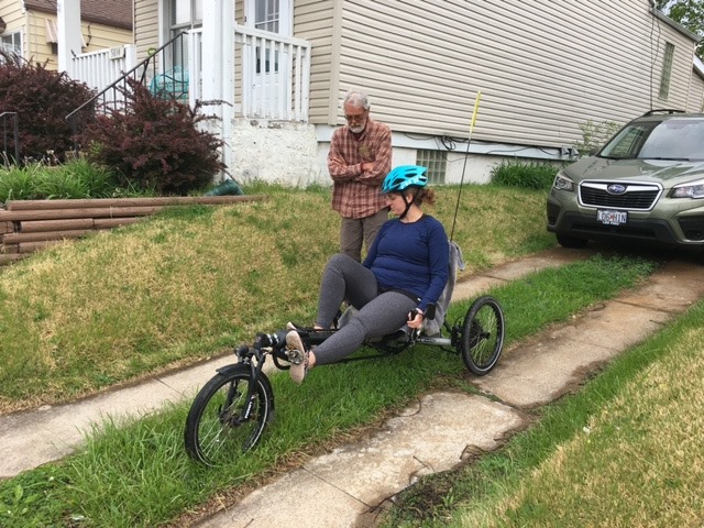
Afterwards, we came back and took turns riding my dad’s electric
“trike.”

IMG_8109

IMG_4776

I was a little nervous to take it out, but I went around a few blocks and it was actually super fun and exhilarating to ride!

Later we cooked dinner and watched the movie Knives Out.

The next day we went to Louie’s mom’s for brunch. Everybody except Louie’s brother Julian was fully vaccinated, and Julian had gotten his second shot just that morning. We had a lovely meal and then took a long walk around Forest Park. It was a hot day, actually, and we enjoyed seeing all the flowers and such. After that it was time for our weekly “roll call” online zoom meeting with the rest of the family and then dinner. We watched the Oscars after dinner for a bit, but went to bed earlier.

I woke up earlier to teach my class but then my parents didn’t leave until a few hours later. It was great to see them, especially after so long, and I hope I didn’t make them walk too much.

They took two days to drive home but did get home safely.

IMG_8129IMG_8134IMG_8128

My mom taught me what some of the flowers were called: I guess this is the first year I’ve really paid attention to what is coming up. Anyway, the second two above are irises Smile

Have you visited the Confluence?


National Parks

I read a book last week by a man who visited all of the National Parks in one year. Don’t get me wrong, I enjoyed reading the book. It wasn’t what I expected though as it was more about him and less about the parks, and I was struck by how different my own travel experiences are. In retrospect, that shouldn’t have surprised me. And of course, his experience as a man traveling is very different than the experience as a woman traveling. Women have to worry about personal safety in a way that no man will ever have to, even when you are traveling with a man, but especially if you aren’t. So reading any travel book by a man, oh, and there are so many, is different than reading a book by a woman, such as Wild by Cheryl Strayed.

However, I was thinking about travel itself, and why I travel, and what traveling has taught me. One of my favorite things to do with Louie is go on a road trip and visit parks and other sites. We love loading up the car and hitting the road, being dirty for a few days, hiking a lot, taking tons of pictures, and finally being grateful to return home. So while visiting National Parks is wonderful, more of our life is spent at home, so how does that affect it?

May be an image of 2 people, including Louis Woodhams and people smiling

Caption: Hiking in Rocky Mountain National Park, going up to the Loch from the Glacier Gorge Trailhead. Summer 2015

The National Parks Service has this “Find Your Park” campaign, and truthfully, my park is Forest Park, which is a huge park near my home in St Louis. I love traveling, and I especially love the mountains. I love seeing wildlife, and getting out into terrain and parts of the country that are very different than where I live, but I don’t want one park. I want them all, and not in a bucket list way, but in the way that I want to experience different places. I have enjoyed returning to places like Yellowstone and Rocky Mountain National Park, but I also have enjoyed seeing new places like Jasper National Park, Colorado National Monument, and Theodore Roosevelt National Park.

No photo description available.

Caption: The Colorado River. I swear there’s a picture somewhere in Louie’s albums of me by the River at the bottom of the Grand Canyon, but I don’t have it. This is a picture I took at the bottom. Spoiler: going down is the easy part. May 2016

The crowds can be an issue. Everybody loves the National Parks! Camping reservations can be hard to get. So another part of the Find Your Park idea can be to find somewhere less popular that may have a more quiet beauty. This summer I am hoping we can travel some, but I’m looking at more off-the-beaten path places that won’t attract the same crowds, but more importantly, don’t require as much advance planning. I just looked at Rocky Mountain NP camping reservations and they are nearly full at my favorite campground for the summer. Not surprising, but we can’t plan a trip until we are vaccinated, and we have no idea when that will be.

May be an image of 2 people, including Louis Woodhams and people smiling

Caption: Great Smoky Mountains, and you can just see how damp it was there. This was walking around an area near Gatlinburg where the fires had burned quite a lot. Our wettest camping trip ever! Summer 2017.

Normally by this time of the year I would have my summer at least mapped out. That may sound crazy to some of you (and it may sound a bit crazy in general) but it was fairly necessary in order to make sure we could fit in various family visits and stuff. It’s all up in the air now, and I hope I get to see my family as well as do a little random traveling.

May be an image of 2 people, including Louis Woodhams

Caption: Glacier National Park, our first views after driving all day from Yellowstone. Each place is new and wonderful, even when the one you left may still be your favorite place. Summer 2019.

IMG_5484

Caption: Standing on a rock at Colorado National Monument, Summer 2016.

But I’ve gotten off topic from my thoughts on the National Parks. Everybody has their own travel style: some like to rough it, others prefer middle-of-the-road comfort, others high end luxury. Some people like to go for a long weekend or a week, others have more time off in a row and can get away longer. Some love flying, others love hitting the open road. Some people like to picnic and cook, others prefer to buy all their food ready-made. Everybody has their own travel style, and of course each trip might be different. I love planning trips almost as much as I love taking them so for me the advance planning is half the fun. Other people hate planning and prefer just to show up. Where am I going with this? Nowhere, it’s my blog Smile But maybe just to say, I want to read the book about somebody who didn’t just hit the road. I want to read the book by somebody who spent as much time planning their trip as doing it! I’m sure that book exists (and I’d like it to be by a woman so I can relate more) or I guess I should write it, ha. If I wrote a book I’d have to edit though, rather than with my blog. (I’m aware people DO edit their blogs, it’s just not something I want to spend a lot of time doing. Yes, I’d probably have more followers.)

May be an image of 2 people, including Louis Woodhams

Caption: On top of Mt. Washburn. Summer 2019.

IMG_6013 - Copy

Caption: Louie in Bryce Canyon, Summer 2016.

IMG_6038

I went down a bit of a memory lane the past hour here, looking at old photos, remembering where we had been, remembering how it felt, remembering arguments we had and remembering wonderful experiences we shared. I recall my wonderment and amazement on the hike in Bryce Canyon. I recall feeling scared on a hike in Zion National Park, and feeling like I’d never be dry again in the Great Smokies. I recall being blown away by Colorado National Monument’s beauty, and also feeling incredibly dirty from not showering for days and being relieved we were out of bear country. I remember enjoying taking the bus out to Athabasca Glacier and feeling sick to my stomach now knowing that there was a horrible accident there last summer in which many people lost their lives. I remember hard work putting up our tent, putting away our tent, and everything that goes with camping, and each night I get into bed here I am grateful for how easy my regular life is.

IMG_5577 - Copy

Caption: Canyonlands National Park, Moab, Utah, Summer 2016

I suppose traveling is never actually about where you go. I mean, it IS, but it’s really about leaving your everyday life to do something special, and try to bring a bit of it back. It’s about finding the special in the mundane as well, and being grateful for the conveniences you have at home, and being more aware of all that you have to feel grateful for.

IMG_7541

Caption: Canary Springs, Mammoth, Yellowstone Summer 2019

As we hope to see the beginning of the end of COVID, we will see how travel has changed, and how COVID has changed us. I don’t see trying to make a big plan for this summer, but there will be a summer soon when Louie has finished his doctorate as well, and I would love for us to hit the road for 3 weeks or so. The cats miss us while we are gone of course, and we miss them, but it’s just so nice to be immersed in not being at home, and so worth it. It does change you, though nobody stays the same anyway, travel or not.

Yellowstone or not: Part 6 The Long Way home

Part 1

Part 2

Part 3

Part 4

Part 5

So we left Silvergate and headed East, the direction home. We wanted to drive the Beartooth Highway en route. Well, Louie did. I was happy to let him drive as I don’t like windy roads!

Oh! I forgot to add this photo from the previous post. Our “Cabin” at the Grizzly Lodge. (You can see it behind the car and the awning).

IMG_6270

It wasn’t quite as nice of a drive on the Beartooth as we’d experienced before because there was CONSTRUCTION and we were stopped for awhile at first. But finally we got going and as always, the views were amazing.

IMG_6271IMG_6285IMG_6278

IMG_6272

We always pass places that look like nice hikes and places to camp, but we never do much as we are en route. Such beautiful sights just off the road though!

IMG_6289

IMG_6290

You can see the road there! This was the top, the Beartooth Pass.

IMG_6296

Louie wanted to stand on the snow.

There were a lot of motorcycle riders around, probably on their way to the super spreading event at Sturgis. We tried to keep our distance.

IMG_6303

The highway ends in Red Lodge and we stopped there for lunch at a place called the Red Box Drive-In. I think I got fried shrimp and fries?

We kept driving then (I drove for awhile, since we were out of the crazy roads) and headed into the Bighorn mountains. We had reserved a spot at Island Park Campground in the Bighorn Mountains. It was a small campground down several miles of dirt road, and we were a little worried about the rain, but the place was great once we got there.

IMG_6322

It was a vault toilet only place but the toilets were clean and the host was really  nice. We tried to just relax and enjoy the evening. We were right by a pond with a little meadow on the other side.

IMG_6323

We walked down to the pond—you can see the tent back up in the trees.

IMG_6329

At night we heard something splashing around in the water and I shined my light towards it. We saw a pair of eyes glowing at us, which was sort of terrifying at first. Finally we discovered it was just a deer so that wasn’t too scary!

The next day we continued driving through the Bighorn Mountains, and took a side road called the Crazy Woman Canyon Drive. I wasn’t “crazy” about the name, but the drive was very cool. You definitely wouldn’t want to drive it in anything without higher clearance though. There were some campsites along the way and nice places to fish probably.

IMG_6344

IMG_6346

IMG_6347

Pretty cool as you can tell! We enjoyed the drive though it had some technical parts.

After that, well, we headed to Nebraska. We did have to go through South Dakota briefly, but didn’t stay long (we were sort of boycotting South Dakota because they didn’t think COVID was real) and ended our evening at Chadron State Park in Nebraska. We set up our tent and went for a short hike on the Black Hills Overlook Trail.

IMG_6350

IMG_6352

There was really interesting scenery! We also ran into a family who were from Missouri—they saw our license plate and struck up a conversation with us.

IMG_6354IMG_6358

IMG_6369

We enjoyed a nice campfire and a good night’s sleep.

The next day we packed up and headed for our last official stop: Carhenge. Carhenge is a bit out of the way but not if you plan on it. Interesting fact (which I learned later) is that my dad spent a week or two in the area at Alliance helping on a combine crew one summer when he was in college. That was before Carhenge was made so he didn’t get to see it.

We were glad we made this stop. It was ridiculous but really cool and fun.

IMG_6377IMG_6374

IMG_6389

IMG_6390

And that was it. After visiting Carhenge, we drove along the Sandhills Scenic Byway through Nebraska for a few hours—definitely nicer than just driving on I-80, and then we joined the interstate and headed to Missouri. We stayed a motel past Kansas City which I have blocked (we were not impressed and would not recommend) the name of in my head, though we had delicious Thai takeout nearby, and then got home around noon the next day. The cats were safe and sound but happy to see us, and we were glad to be home and safe. Time went by and it didn’t seem we caught COVID on our trip, and I was glad we went. It was just what we needed at the time, both to get out of the house and see other places, and to be able to leave the house without being really scared and panicky. I think we were as safe from COVID as we could be, and we never set foot inside a building without a mask on.

I hope you enjoyed reading about my trip! Until the next one…it’ll be regular blog posts for awhile now.

Yellowstone or not: Part 5, Includes a rather Grand Canyon

Part 1

Part 2

Part 3

Part 4

I am aware of the fact that over a month has gone by since the last trip recap, but I have had this on my to-do list and so today I shall proceed. Life has been pretty busy at home, even without the usual concert schedule (mostly because I still managed to take on more work, which is both great and not great.)

We woke up at Bridge Bay Campground again, for our last full day in the park. Our plan was to go early to the Grand Canyon of the Yellowstone and hike the South Rim to Clear Lake Trail we had done about 5 years before.

You can’t get from Bridge Bay to the Canyon area without running into a bison jam though.

IMG_6069

Or without seeing one just out standing in his field. This one had some branches stuck on his horns, how embarrassing for him.

IMG_6076

We easily found the place to park (I remembered it from the previous time) and set off on our hike. I believe it was supposed to be about 5 miles RT or so. The beginning was beautiful, with great views of the Falls, Canyon, and the Yellowstone River. Some of the path seemed different than before and I think they had rerouted some of it and fixed up other parts. Also Uncle Tom’s Stairs were closed, but I had decided after last time that I was done climbing up and down those stairs anyway. (It’s not the climb, it’s that they are open metal stairs along the side of a steep cliff near a rushing River.)

IMG_6081

This was the sort of view along the way.

Now, this was one of the more crowded hikes, as we figured. We did have masks on for the crowded parts, though not enough other people did. Another note: if you are a hiker or a walker, don’t take the shortcut paths that the park service has worked so hard on marking with signs NOT to take, take the slightly longer way so they can grow out the vegetation and stop the erosion. I get so annoyed when people can’t just walk around, especially when it is really clear you are supposed to.

IMG_6098

We saw a little deer along the way as well. I think it was a few here, but only one in my photo. I suppose one of the downsides of waiting over 2 months to write a blog post is that I’m going, hmm, how many deer were there, was this near where I stopped to pee in the woods? and truthfully, who knows. Maybe Louie has pictures, but he is just as behind at going through them as me!

IMG_6108

The South Rim trail meanders along the South Rim of the Canyon. (And yes, there is a North Rim which we visited the previous year and weren’t planning to bother with this time.) You can drive and park at various lookouts but it’s much nicer if you are able to just walk.

IMG_6112

There are varying rumors and stories of how the name Yellowstone came to be. One is because of the yellow rocks by the Canyon area. I would buy it!

IMG_6136

You can see we are getting farther from the Falls.

Canyonselfie

Selfie! I believe this was at Artist Point, the most popular lookout along the South Rim.

IMG_6148

Next the trail meanders into the woods and heads towards Lily Lake (and then Clear Lake).

IMG_6152

The trail also goes by a variety of thermal features. It wasn’t as magical this time through, probably because we’d already seen them, and also it was getting HOT! and it was very sunny.

ClearLake Selfie

There were some people annoyingly camped out along the lake, not camped literally, but they had chairs and were just hanging out for whatever reason, and they were sitting in a way that they tended to be in almost any photo you tried to take. Which is super obnoxious when you are still 2 miles from the parking lot!

Anyway, Clear Lake is green and is pretty acidic due to the thermal activity and whatnot. I’m not a geologist, but it’s something like that.

Then we walked through the blinding sunlight to get back to the parking area. We decided after that to walk to the Brink of the Upper Falls since it had been closed the previous year for construction. It was a neat little walk because it went over what used to be a bridge taken by cars but was now just a footbridge. The bridge was built in the 1890’s first as a wooden arch bridge and then was replaced by this one in 1914-1915. It is no longer used by cars—I know I read somewhere when it was replaced for car use but I can’t find it now.

IMG_6182

Anyway, it was a fairly short walk (less than a mile?) to the Brink of the Upper Falls and we were glad we popped over. You can also imagine the Brink was crazy busy, probably the most crowded place we had been.

IMG_6183

After that we headed south. We didn’t have any more specific plans but thought it would be fun to drive to the South entrance of the park so that we would have driven every mile of the main roads during our 10 nights here.

We made some stops along the way at random places.

IMG_6199IMG_6205IMG_6206

I think this might have been Lewis Lake or another Lake and I looked up and realized the trees were just like that!

IMG_6211

As we got further south we could see the Tetons and suddenly regretted we hadn’t decided to spend some time there. Don’t get me wrong, we loved our Yellowstone time, but there are always more places to visit, and now we want to see the Tetons again. I think another year, after COVID is done will be better, as it’s a smaller park with more people crowded into a smaller area.

After getting all the way south, we headed back up north towards Bridge Bay again. There was a gravel bar along the Lake that Louie wanted to check out—it was a long gravel bar that you could walk along.

IMG_6218IMG_6219

Anyway, we finally got back to our tent site and we were early enough that we took showers with our portable shower set up.

IMG_6221

We had an early night, with a nice fire first to burn up all the wood.

The next morning we packed up and headed out. Our end of the day stop would be out the Northeast Gate of the Park, a cabin in a tiny town called Silvergate. But first, some stops along the way, of course!

IMG_6222

We had to go by Mammoth again in order to get out of the park through the north  (the more direct route was closed due to construction). We went into Gardiner again if I recall and thought we’d get another smoothie but the place wasn’t open yet. We also checked email and such and then headed towards our hike destination for the (early afternoon) day. Slough Creek Road. People said it was a great road for seeing wildlife in the morning and evening, but it was the heat of the day. Oh well.

I wasn’t feeling too good by now for whatever reason, maybe too many peanut butter sandwiches and peanuts, but we decided to do the hike—it was an out-and-back, and we were only planning to hike about 4 miles. The hike could continue for miles and miles and one could backpack, and we definitely saw people in the parking lot returning from and getting ready for such hikes.

IMG_6229

In any case, I was a little crabby for this hike: it was hot, I was tired (we both were) but you know what, the scenery sure was beautiful! So we hiked along, and at one point a guy was coming towards us and he stopped and was telling us that there was a young black bear that had been on the path and he managed to scare it off the path finally by throwing rocks towards it and he thought it wasn’t following him anymore. I was confused by what he saying at first and asked did he want us to hike with him but he said, no, he was just telling us, that we might see it, and if we got the Ranger cabin and didn’t see it we probably were fine. Okay! So Louie wasn’t sure if I’d want to continue, but I figured, well, we’ve got our bear spray, that guy didn’t seem too scared, and he said the bear wasn’t bothering him too much. So off we went, singing and talking to make noise.

IMG_6231

This may have been some of the most gorgeous scenery in the park. Well, with the exception of the Lake Yellowstone area.

IMG_6232

So we saw the cabin, and that was basically where we planned to turn around. We hadn’t seen the bear yet, and I thought, well, maybe we’d better do our plan and turn back in case going on meant we DID see the bear. We also ran into a father-son hiking team and were telling them what we’d heard but they already knew and had had a bear story of their own. Well, we went on our separate ways, and we turned back, and then suddenly, Louie saw the bear, up on a ridge right near the trail. So we stopped and watched, and then lost him for a minute, and then he was right up on the trail ahead of us.

IMG_6238

So we had choices to make, do we stay nearby to keep an eye on the bear, who seemed to be slowly meandering down the exact path we needed to take, or did we stay 100 yards away, but then we might lose track of the bear and inadvertently get closer again? We decided to stay as far away as we could keep him in sight. We figured the bear knew we were there, but the bear didn’t seem bothered by us, so we wanted to keep it that way. We kept talking and saying nice things about him while walking down the path slowly. Finally after what seemed like an eternity, the bear had gone off the path quite some distance, so we slowly walked by (and then walked backwards for some time) until we felt a safe distance had passed. It was scary but thrilling!

Here’s a video of it!

We finished up the hike then, telling a few more hikers we passed about the bear so they would be ready, and then got back in the car. We headed through Lamar Valley again…it was getting gloomy with rain looking likely, so we decided to head out to Silvergate, with the idea we might come back in later. Along the way we saw that a couple on a motorcycle had left a small bag at a parking pullout as they left and we tried to get their attention to tell them. Louie was honking and we were waving, and we almost caught them but they sped off. We felt bad for them, and we felt bad because people around us might have thought we were jerks…we may have yelled at them just in front of a bison jam, but then we never did get them to understand, and then we felt bad all around: that a motorcycle couple would think we would be angry at them and honking for that reason, that we missed enjoying the bison jam because we were trying to get their attention to tell them they left a bag on the ground, and ugh, just tired and probably the aftermath of seeing the bear.

IMG_6250

So we went to the Grizzly Lodge in Silvergate, and checked in to our cabin. Their COVID protocol seemed to be to sort of avoid people but not wear a mask. It was a bit strange. We also met an old couple who seemed nice enough but told us that there weren’t any restaurants in Silvergate open past 5 pm and also the man was wearing a MAGA hat, which didn’t make us feel very good. It turned out he was lying or mistaken and that in fact there was a nice restaurant right next to the hotel than served dinner until normal dinner hours.

Our cabin was cute, but wasn’t really a cabin as I was imagining as it was right next to the hotel.

IMG_6252IMG_6254

We got cleaned up and then went for dinner at the Log Cabin Cafe. We ate outside and we felt okay about this because we could see that the tables were well spaced out. The rain seemed to have either passed through or missed us, so it was a nice evening, except for some mosquitoes.

IMG_6256

IMG_6257

I

I had the trout dinner and it was delicious. This was the first time we had eaten at a sit-down restaurant since Atlanta in March, and it was really nice to have somebody bring your food and drinks and then take your dishes away!

IMG_6258

The next morning we ate breakfast there and it wasn’t quite as good due to the service. The server was overwhelmed (I think they must have been understaffed) but we still got a decent meal outside, but it started pouring right after we ate and I’m sure some outside people got wet.

We had originally thought we might go back into the park but once we left we were done. It was time to move on and start heading home.

Okay, I’m going to stop there and leave one more post to get us home.  Keep your eyes peeled, it won’t be long!